Please click on images to enlarge them.


Formation of Chemung County, New York
Including the History of Montgomery County
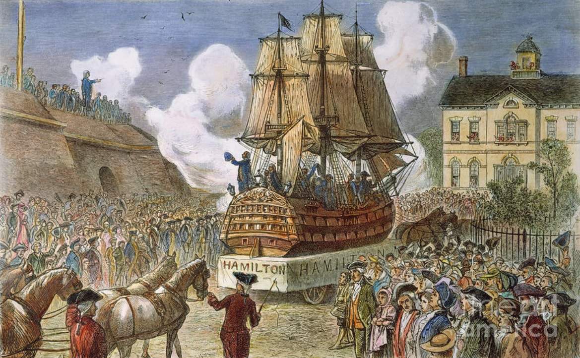
The year of Incorporation in the new town of Chemung, NY in Montgomery County. NEW YORK PARADE, 1788. The celebration in New York City following the ratification of the Federal Constitution on 26 July 1788 colored engraving, 19th century. (Fine Art America)
The Formation of Chemung County: including Montgomery County & a short history of New York State
The first Dutch settlement was established in 1624. For 40 years the Dutch ruled over the colony of New Netherland, (New York). As late as 1638 the area of land lying to the west of Fort Orange (Albany), was called the "Terra Incognita" or Unknown Land.
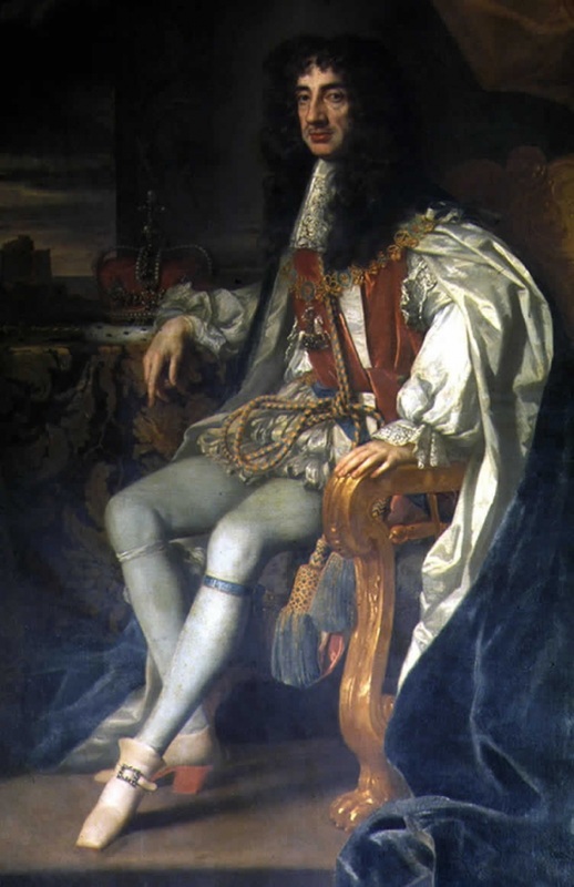
The territory that comprised New Netherlands was a constant contention between the English and Dutch. In the year 1664, the British army conquered the colony of New Netherland, which was then re-named New York, in honor of the Duke of York and Fort Orange renamed as Albany. King Charles II of England granted the whole of New Netherlands to his brother James, the Duke of Albany and York. The conquering of New Netherlands by force of arms was done quite successfully as the inhabitants were weary of Petrus Stuyvesant, Dutch director-general of New Netherlands. c 1610-1672.
In 1673 the Dutch once again reclaimed the territory and held it for one year before surrendering it to the English. Doubts regarding the validity of the patent, given the Duke of York, resulted in a new patent being given by the King.
As peace was restored with the Dutch, internal growth rapidly commenced. In the year 1683 the colony was divided into twelve counties. Albany County swallowed a large portion of the “Terra Incognita” Unknown Land. Albany County actually occupied all the colony of New York north of Ulster County and west of the Hudson River along with all the area north of Duchess County and eastward of that river. It was a vast tract of land. It would be another century before Albany County was divided again.
1754 - 1763 The French and Indian War. The British and American colonists fought against the French and Canadians, with Native American allies on both sides. By uniting the colonies and building their military strength and confidence, this war set the stage for the American Revolution. In 1765 New York City hosted the first Colonial Congress, a conference called to discuss the King of England's Stamp Act.
In the year 1772, from the Territory of Albany County, the counties Charlotte and Tryon were formed. Charlotte County changed its name in 1772 to Washington County. A part of Charlotte County was included in the counties of Cumberland and Gloucester in forming the state of Vermont. The later, named for William Tryon, Colonial Governor and Loyalist, “who exhibited such unmistakable hostilities to the Americans that the inhabitants of this county were desirous of dispensing with a name thus rendered obnoxious”.
The New York Provincial Congress (1775-1777) was an organization formed by colonists in 1775, during the American Revolution, as a pro-American alternative to the more conservative Province of New York Assembly, and as a replacement for the Committee of One Hundred. It was assembled by Rebels when the Provincial Legislature would not send delegates to the Continental Congress.
1775 - 1783 The Revolutionary War. On May 10, 1775, Ethan Allen, Benedict Arnold and 83 “Green Mountain Boys” surprised the sleeping British garrison at Fort Ticonderoga and took the fort called the Key to a Continent without firing a shot. This was the first American victory of the Revolutionary War.
After serving as a colony of Great Britain for over a century, New York declared its independence on July 9 1776, becoming one of the original 13 states of the Federal Union
In 1777 New York's first constitution was adopted on April 20. George Clinton was elected as New York’s first Governor in June. On October 17, the Americans defeated the British at the Battle of Saratoga, one of the decisive battles of the war. This victory marked the turning point of the Revolution, leading to the Americans’ alliance with the French and eventual victory.
George Clinton, who first took office on July 30, 1777, served seven terms in two different periods, totaling just under 21 years in office. ( 18 of those years were consecutive, Clinton also served the longest consecutive period in office for a New York governor.)
On November 25, 1783 the last British troops evacuated New York City, which had been occupied by the British since September 1776. This was the last British military position in the US. After they departed, US General George Washington entered the city in triumph to the cheers of New Yorkers.
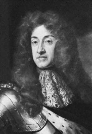
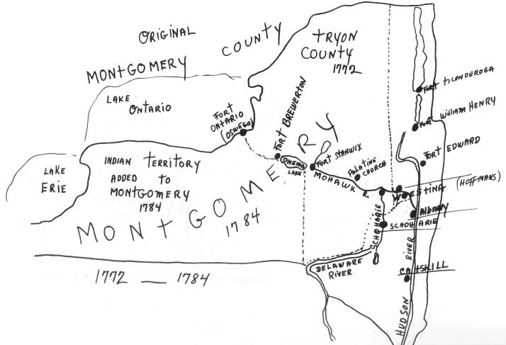
On April 2, 1784, Legislature changed the name of Tryon County to Montgomery, in honor of the American General, Richard Montgomery, who gallantly fell at Quebec. Montgomery County embraced all that part of the State, west of a line running nearly north and south through the present County of Scoharie. It was by the same act, Montgomery County was divided into five districts, named Mohawk, Canajoharrie, Palatine, German Flats, and Kingsland.
On March 7, 1788, another act passed defining the boundaries of the several counties of the State. The County of Montgomery was declared to contain all that part of the State bounded easterly by the counties of Ulster, Albany, Washington and Clinton; southerly by the State of Pennsylvania; and westerly and northerly by the west and north bounds of the state. Another act passed on March 22, 1788, from which the legislature erected a new town in Montgomery County, the Town of Chemung, lying on the Owego and Tioga Rivers:
This tract covers the present day towns of Barton and the greater portion of Tioga County and the towns of Southport, Elmira, Ashland, Baldwin & Chemung along with a portion of Big Flats, Horseheads, Erin and Van Etten in Chemung County. A dissension broke out among the settlers who could not agree on a division of their location while being concerned for their possessions and looking for assignment and allotted lands to the claimants who had already settled on the lands and made improvements. In the act of erecting the town, the Legislature appointed John Castine, Brigadier General James Clinton, (son of Governor George Clinton) and John Hathorn, Commissioners to inquire into and settle the dispute. The allotments were not to be less than 100 nor more than 1,000 acres each and also provided that the lands were to be settled within three months after the state had acquired the Indian title. The lands were to be bought at one shilling and six pence per acre. They proceeded to survey and plot the town. On February 27th, 1789, the legislature confirmed their report and authorized the commissioners of the Land Office to patent the lands to the parties named on the lots on the maps submitted by the commissioners of this town and extended the time of settlement to one year after the state had acquired the Indian title. Certificates of location were issued by the commissioners, which were assignable and thus parties acquired large tracts, which were patented to them under one patent. Some of the large tracts granted in the old town of Chemung were as follows: To Isaac D. Fonda, Jacob Ford, Peter W. Yates, Josiah Richardson and Thomas Klump. “Certificates of location, 8,000 acres on northwest bank of Susquehanna River, now in Tioga, Tioga County, January 26th 1789. Vol. 46, page 25 Land Papers”.
An act passed on the same date: March 7, 1788 and the German Flats District was divided. The town of Whites Town was formed from it. This town embraced all that part of the State of New York, lying west of a line drawn north and south across the State, crossing the Mohawk River at “Old Fort Schuyler”, (Utica) and which line was the western boundary of the towns of Herkimer, German Flats and Otsego.
In 1789, the County of Montgomery was divided, and all that part west of a line drawn north and south across the State, through the Seneca Lake two miles east of Geneva, was called Ontario County, and was extensively known abroad as the "Genesee Country." It included all the land of which pre-emption right had been ceded to Massachusetts.
Feb. 16, 1791, Montgomery County was divided once again, and the Counties of Tioga, Otsego and Herkimer formed from its territory, and the bounds of the County of Ontario changed.
The other counties in the state continued to form new boundaries. This short article gives insight into the growing pains of forming the counties and later the formations of the towns of our great state of New York.
“The township of Chemung, erected in 1788, comprised precisely the territory that afterward became the county of the same name, with the exception of a portion of the township of Cayuta, Schuyler County; That is, it included not only what is at present Chemung County, but also the towns of Catherine, Dix and Montour in Schuyler County. It contained fifty-three square miles of land, which would be a rather good-sized township in this State. There were less than 1,000 inhabitants within its whole limits and these were scattered up and down the valley from Chemung to Big Flats, with the beginnings of future villages at or near Chemung, Elmira, Watkins and “Mill’s Landing”, now Havana, Schuyler County.”
Portions of the territory of old Montgomery County, county seat at Fonda, were constantly taken from it until now it is one of the smallest in the State, having only six square miles more than the original township of Chemung.
Newtown (Elmira) was laid out in 1790. In 1791 Tioga County was formed from Montgomery County along with Chenango Point, (Chenang Pint), now Binghamton. Tioga County was organized on February 16, 1791 and was composed of the present counties of Chemung, Broome and Tioga with portions of the counties of Schuyler, Tompkins, Cortland and Chenango.
In 1791 the final treaty with the Six Nations was signed in Newtown.
Newtown Township became Elmira on April 6, 1808 but the Village of Newtown retained their name. The Village of Newtown was incorporated in March 1815 and its name changed to Elmira on April 21, 1828.
The township of Elmira lost territory on April 16, 1822 with the southern portion south of the river becoming Southport and a northwestern part, Big Flats. The next year on April 16, 1823, the southern end of the township of Catherine was cut away from it and made into the new townships of Veteran on the east half and Catlin on the west half. It was on April 17, 1835 that the northern half of Catlin was taken to form the township of Dix. It became and is now a portion of the county of Schuyler. On March 20, 1824, land was taken from the township of Spencer and was formed into the township of Cayuta, which is also a portion of Schuyler County.
“March 29, 1836, Chemung County was organized by the legislature. It comprised the present territory of the county along with the towns of Catherine, Dix, Montour and Cayuta in Schuyler County”. On February 7, 1854 the Legislature authorized Horseheads to set up for a township by itself. In the spring of 1854 the northern portion of Chemung County being, towns of Catherine, Dix and part of Cayuta was taken away to form Schuyler County with a slice from Steuben and Tompkins.
When Schuyler County was formed, April 17, 1854, a small portion of the township of Cayuta was saved to Chemung County and that along with a portion from Erin township was erected and became the township of Van Etten.
On April 7, 1856, legislature passed an act creating another new township, Baldwin which was made up from the northern part of Chemung “up Wynkoop Creek, as it might be termed in that locality”. Interestingly two post offices were established in the township, Hicks and North Chemung, although the latter is better known locally as “Hammond’s Corners”.
Elmira was incorporated as a city on April 7, 1864. In 1850 it was authorized to have two members to represent it in the Board of Supervisors and in 1854 it was divided into three wards. The third ward being on the south side of the river and taken in from the town of Southport as a part of the village. The town of Ashland was formed in 1867 from parts of the towns of Chemung, Elmira and Southport.
References
** History of Madison County, NY (State of New York)
** Old Town of Chemung, Montgomery County, by Capt. Charles L. Albertson
** History of Chemung County New York 1836-1892 by Ausburn Towner
The first Dutch settlement was established in 1624. For 40 years the Dutch ruled over the colony of New Netherland, (New York). As late as 1638 the area of land lying to the west of Fort Orange (Albany), was called the "Terra Incognita" or Unknown Land.
The territory that comprised New Netherlands was a constant contention between the English and Dutch. In the year 1664, the British army conquered the colony of New Netherland, which was then re-named New York, in honor of the Duke of York and Fort Orange renamed as Albany. King Charles II of England granted the whole of New Netherlands to his brother James, the Duke of Albany and York. The conquering of New Netherlands by force of arms was done quite successfully as the inhabitants were weary of Petrus Stuyvesant, Dutch director-general of New Netherlands. c 1610-1672.
In 1673 the Dutch once again reclaimed the territory and held it for one year before surrendering it to the English. Doubts regarding the validity of the patent, given the Duke of York, resulted in a new patent being given by the King.
As peace was restored with the Dutch, internal growth rapidly commenced. In the year 1683 the colony was divided into twelve counties. Albany County swallowed a large portion of the “Terra Incognita” Unknown Land. Albany County actually occupied all the colony of New York north of Ulster County and west of the Hudson River along with all the area north of Duchess County and eastward of that river. It was a vast tract of land. It would be another century before Albany County was divided again.
1754 - 1763 The French and Indian War. The British and American colonists fought against the French and Canadians, with Native American allies on both sides. By uniting the colonies and building their military strength and confidence, this war set the stage for the American Revolution. In 1765 New York City hosted the first Colonial Congress, a conference called to discuss the King of England's Stamp Act.
In the year 1772, from the Territory of Albany County, the counties Charlotte and Tryon were formed. Charlotte County changed its name in 1772 to Washington County. A part of Charlotte County was included in the counties of Cumberland and Gloucester in forming the state of Vermont. The later, named for William Tryon, Colonial Governor and Loyalist, “who exhibited such unmistakable hostilities to the Americans that the inhabitants of this county were desirous of dispensing with a name thus rendered obnoxious”.
The New York Provincial Congress (1775-1777) was an organization formed by colonists in 1775, during the American Revolution, as a pro-American alternative to the more conservative Province of New York Assembly, and as a replacement for the Committee of One Hundred. It was assembled by Rebels when the Provincial Legislature would not send delegates to the Continental Congress.
1775 - 1783 The Revolutionary War. On May 10, 1775, Ethan Allen, Benedict Arnold and 83 “Green Mountain Boys” surprised the sleeping British garrison at Fort Ticonderoga and took the fort called the Key to a Continent without firing a shot. This was the first American victory of the Revolutionary War.
After serving as a colony of Great Britain for over a century, New York declared its independence on July 9 1776, becoming one of the original 13 states of the Federal Union
In 1777 New York's first constitution was adopted on April 20. George Clinton was elected as New York’s first Governor in June. On October 17, the Americans defeated the British at the Battle of Saratoga, one of the decisive battles of the war. This victory marked the turning point of the Revolution, leading to the Americans’ alliance with the French and eventual victory.
George Clinton, who first took office on July 30, 1777, served seven terms in two different periods, totaling just under 21 years in office. ( 18 of those years were consecutive, Clinton also served the longest consecutive period in office for a New York governor.)
On November 25, 1783 the last British troops evacuated New York City, which had been occupied by the British since September 1776. This was the last British military position in the US. After they departed, US General George Washington entered the city in triumph to the cheers of New Yorkers.
On April 2, 1784, Legislature changed the name of Tryon County to Montgomery, in honor of the American General, Richard Montgomery, who gallantly fell at Quebec. Montgomery County embraced all that part of the State, west of a line running nearly north and south through the present County of Scoharie. It was by the same act, Montgomery County was divided into five districts, named Mohawk, Canajoharrie, Palatine, German Flats, and Kingsland.
On March 7, 1788, another act passed defining the boundaries of the several counties of the State. The County of Montgomery was declared to contain all that part of the State bounded easterly by the counties of Ulster, Albany, Washington and Clinton; southerly by the State of Pennsylvania; and westerly and northerly by the west and north bounds of the state. Another act passed on March 22, 1788, from which the legislature erected a new town in Montgomery County, the Town of Chemung, lying on the Owego and Tioga Rivers:
- The boundary line beginning at the intersection of the pre-emption line of Massachusetts with the Pennsylvania State line and running north from the point of intersection, along the pre-emption line for a distance of two miles north of the Tioga River; thence, in a direct line at right angles to the pre-emption line east to the Owego River, to intersect said river at a distance of four miles on a straight line from the confluence there of with the Susquehanna River; thence down the Owego and Susquehanna to the Pennsylvania state line; and thence along the said line to the place of beginning.
This tract covers the present day towns of Barton and the greater portion of Tioga County and the towns of Southport, Elmira, Ashland, Baldwin & Chemung along with a portion of Big Flats, Horseheads, Erin and Van Etten in Chemung County. A dissension broke out among the settlers who could not agree on a division of their location while being concerned for their possessions and looking for assignment and allotted lands to the claimants who had already settled on the lands and made improvements. In the act of erecting the town, the Legislature appointed John Castine, Brigadier General James Clinton, (son of Governor George Clinton) and John Hathorn, Commissioners to inquire into and settle the dispute. The allotments were not to be less than 100 nor more than 1,000 acres each and also provided that the lands were to be settled within three months after the state had acquired the Indian title. The lands were to be bought at one shilling and six pence per acre. They proceeded to survey and plot the town. On February 27th, 1789, the legislature confirmed their report and authorized the commissioners of the Land Office to patent the lands to the parties named on the lots on the maps submitted by the commissioners of this town and extended the time of settlement to one year after the state had acquired the Indian title. Certificates of location were issued by the commissioners, which were assignable and thus parties acquired large tracts, which were patented to them under one patent. Some of the large tracts granted in the old town of Chemung were as follows: To Isaac D. Fonda, Jacob Ford, Peter W. Yates, Josiah Richardson and Thomas Klump. “Certificates of location, 8,000 acres on northwest bank of Susquehanna River, now in Tioga, Tioga County, January 26th 1789. Vol. 46, page 25 Land Papers”.
An act passed on the same date: March 7, 1788 and the German Flats District was divided. The town of Whites Town was formed from it. This town embraced all that part of the State of New York, lying west of a line drawn north and south across the State, crossing the Mohawk River at “Old Fort Schuyler”, (Utica) and which line was the western boundary of the towns of Herkimer, German Flats and Otsego.
In 1789, the County of Montgomery was divided, and all that part west of a line drawn north and south across the State, through the Seneca Lake two miles east of Geneva, was called Ontario County, and was extensively known abroad as the "Genesee Country." It included all the land of which pre-emption right had been ceded to Massachusetts.
Feb. 16, 1791, Montgomery County was divided once again, and the Counties of Tioga, Otsego and Herkimer formed from its territory, and the bounds of the County of Ontario changed.
The other counties in the state continued to form new boundaries. This short article gives insight into the growing pains of forming the counties and later the formations of the towns of our great state of New York.
“The township of Chemung, erected in 1788, comprised precisely the territory that afterward became the county of the same name, with the exception of a portion of the township of Cayuta, Schuyler County; That is, it included not only what is at present Chemung County, but also the towns of Catherine, Dix and Montour in Schuyler County. It contained fifty-three square miles of land, which would be a rather good-sized township in this State. There were less than 1,000 inhabitants within its whole limits and these were scattered up and down the valley from Chemung to Big Flats, with the beginnings of future villages at or near Chemung, Elmira, Watkins and “Mill’s Landing”, now Havana, Schuyler County.”
Portions of the territory of old Montgomery County, county seat at Fonda, were constantly taken from it until now it is one of the smallest in the State, having only six square miles more than the original township of Chemung.
Newtown (Elmira) was laid out in 1790. In 1791 Tioga County was formed from Montgomery County along with Chenango Point, (Chenang Pint), now Binghamton. Tioga County was organized on February 16, 1791 and was composed of the present counties of Chemung, Broome and Tioga with portions of the counties of Schuyler, Tompkins, Cortland and Chenango.
In 1791 the final treaty with the Six Nations was signed in Newtown.
Newtown Township became Elmira on April 6, 1808 but the Village of Newtown retained their name. The Village of Newtown was incorporated in March 1815 and its name changed to Elmira on April 21, 1828.
The township of Elmira lost territory on April 16, 1822 with the southern portion south of the river becoming Southport and a northwestern part, Big Flats. The next year on April 16, 1823, the southern end of the township of Catherine was cut away from it and made into the new townships of Veteran on the east half and Catlin on the west half. It was on April 17, 1835 that the northern half of Catlin was taken to form the township of Dix. It became and is now a portion of the county of Schuyler. On March 20, 1824, land was taken from the township of Spencer and was formed into the township of Cayuta, which is also a portion of Schuyler County.
“March 29, 1836, Chemung County was organized by the legislature. It comprised the present territory of the county along with the towns of Catherine, Dix, Montour and Cayuta in Schuyler County”. On February 7, 1854 the Legislature authorized Horseheads to set up for a township by itself. In the spring of 1854 the northern portion of Chemung County being, towns of Catherine, Dix and part of Cayuta was taken away to form Schuyler County with a slice from Steuben and Tompkins.
When Schuyler County was formed, April 17, 1854, a small portion of the township of Cayuta was saved to Chemung County and that along with a portion from Erin township was erected and became the township of Van Etten.
On April 7, 1856, legislature passed an act creating another new township, Baldwin which was made up from the northern part of Chemung “up Wynkoop Creek, as it might be termed in that locality”. Interestingly two post offices were established in the township, Hicks and North Chemung, although the latter is better known locally as “Hammond’s Corners”.
Elmira was incorporated as a city on April 7, 1864. In 1850 it was authorized to have two members to represent it in the Board of Supervisors and in 1854 it was divided into three wards. The third ward being on the south side of the river and taken in from the town of Southport as a part of the village. The town of Ashland was formed in 1867 from parts of the towns of Chemung, Elmira and Southport.
References
** History of Madison County, NY (State of New York)
** Old Town of Chemung, Montgomery County, by Capt. Charles L. Albertson
** History of Chemung County New York 1836-1892 by Ausburn Towner
1784 Montgomery County, New York
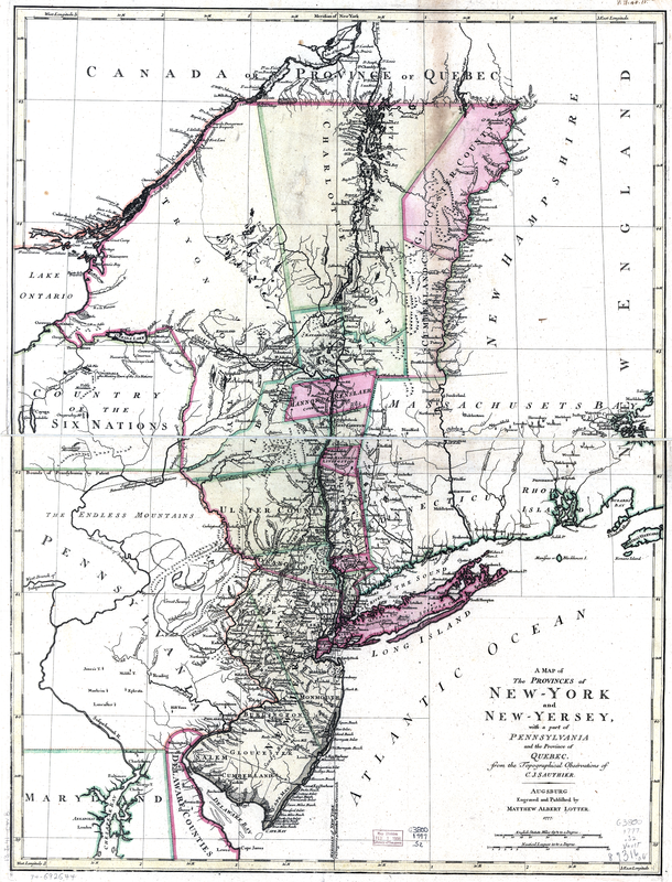
New York 1777 Map
