Cemeteries - Town of Chemung, NY
and a few from other bordering communities
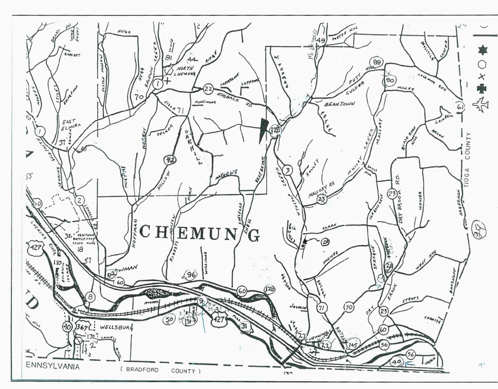
Map of Town of Chemung with reference to the location of the cemeteries in the town.
To view my Headstone Replacement Project, click here.
|

|
|
Cemeteries and Burial Plots in the Town of Chemung, Chemung County, New York, Taken from the Association of Municipal Historians of NYS, NY
State Cemeteries Name/Location Survey Project. (1995). Many thanks to our past historian, Joan Shafer for compiling this information.
You will find this map has circled numbers that give us an approximate location of the cemeteries in the town of Chemung, It is a little confusing with the route numbers also being circled. A description of the location should help you to narrow the search area.
(A listing of old burial plots that no longer exist can be located at the bottom of the page)
|
Map Number Name of Cemetery
#9 Batterson #22 Chemung Village #23 Cooley #27 Drake #28 Dry Brook #145 Dry Brook/Wyncoop #31 Dutchtown #89 Fred Price #40 French # 90 Harvey Price #50 Hillman's #61 Lockwood #62 Lowman Farm #89 Price Cemetery #1 #90 Price Cemetery #2 #96 Riverside #128 Warren #129 Warren Flats #131 Wells (Hilltop) #145 Wynkoop/Drybrook #132 Wellsburg Baptist Church Cemetery |
Cemetery Descriptions
(Click on links below to take you to the appropriate page) #9, Batterson Burial Ground GPS# 42.020754,-76.668025 (This gps is not exact, but very close) On the north side of Wilawana Road (Rt 427), 3 & 2/10ths miles east of the Village of Wellsburg and 2 & 3/10ths miles west of the NY/PA line, about 700 feet north of the road, behind a barn, Town of Chemung. (Deserted, no apparent cemetery group or care.) Private Property. First burial 1835, Last burial 1848. According to area residents, most of the markers have been removed. #22 Chemung Village Cemetery GPS# 42.010817,-76.615370 On the south side of North Street, 2/10ths of a mile east of the intersection of North and Hamilton Streets, Chemung hamlet, Town of Chemung. (Incorporated Cemetery-Not for Profit, Religious Cemetery) First Burial 1795. Last Burial, current. #23 Cooley Cemetery GPS# 42.041387,-76.625585 On the east side of County Route 3, about 3 & 4/10ths miles north of the intersection of County Rts. 3 and 60 about 20 feet east of the highway. (Family Cemetery over 10 burials. Inactive) |
#27 Drake Cemetery
GPS# 42.011155,-76.628303
On the north side of County Route 60, 2/10th’s of a mile west of the intersection of County Rt 60 and 3 (Wyncoop Creek Rd.), Chemung hamlet, Town of Chemung. Family Cemetery, under 50 burials. (Deserted, no apparent cemetery group.) 2017-2018 clean up project under way.
#28 Dry Brook Cemetery
GPS# 42.030175,-76.585899
On the west side of County Rt 23, about 1/10th mile north of the intersection of County Rt 23 and 50 and south of Clark Rd. Town of Chemung. (Deserted-no apparent cemetery group) (This was not a family cemetery, but rather a community one. However, it was never incorporated – just cared for by individuals. I could find no one who claimed to have records or responsibility for it.-Joan Shafer)
#145 Dry Brook/Wynkoop Cemetery - see Wynkoop/Dry Brook
#31 Dutchtown Cemetery
GPS# 42.012037,-76.649021
Dutchtown Cemetery on the north side of Wilawana Rd. (State Rt 427), about 4 & ½ miles east of the Village of Wellsburg and 1 & 1/10th miles west of the NY/PA line, on the edge of an elevated field on the west side of Passmore Rd, Town of Chemung. (over ten burials-maintained by local residents, no records) First burial 1811, last burial 1903)
#89 Fred Price - see Price Cemetery #1
#40 French Cemetery
GPS# 42.005236,-76.579075
On the south side of County Rt 56, about 5/10th’s of a mile east of the intersection of County Rt 56 and State Rt 17 (Exit 59A) about 500 feet from the PA and Tioga County lines, in the hedgerow of a field, Town of Chemung. (Family Cemetery, over 10 burials. Deserted-no apparent cemetery group.)
#90 Harvey Price - see Price Cemetery #2
(Old) Hilliker Farm Burial Plot
on Hilliker Road, Chemung, NY (not numbered on the map)
#50 Hillman's Burial Plot
May have been on the north side of Wilawana Rd. (St. Rt 427), on the river flats about 3 & 8/10’s miles west of the NY/PA line, vicinity of Hillman and Tanner properties, Town of Chemung. ( I spoke with Mr. Tanner and Mr. Hillman, whose families have lived in the area for more than one hundred years. Neither could recall ever having heard of a cemetery in that area.-Joan Shafer)
#61 Lockwood Cemetery
GPS# 42.090119,-76.551422
West of Church Street, about 1 & 5/10th’s of a mile from the intersection of Main and Church St. in Lockwood Village, north of Campbell Hill Rd, south of Lockwood Run, partly in Tioga and Chemung Counties, on a knoll beside an unpaved access road, Town of Chemung. (Incorporated Cemetery – Not for profit, Religious Cemetery. Earliest burial 1838 Latest burial - current).
#62 Lowman Burial Plot
Lowman Farm Cemetery, presumed to be in the area near Lowman Rd and County Rt 60, Town of Chemung. (I spoke with Mr. Jason Knapp on whose property this burial site is indicated. He had no knowledge of it, and his family resided in the area since 1930. His wife, Mary, was the former Town Historian, and she had not mentioned it’s existence.- Joan Shafer).
#89 Price #1 Burial Plot
Approximate: GPS# 42.103490,-76.590160
UPDATE: Feb 2017, a list of this cemetery was located at the Tioga Point Museum, from C.W. Northrop, June 1935.
North of Put (Putnum) Hill Rd, and west of Simcoe Hill Rd, in the woods along an abandoned logging road, Town of Chemung.(Area residents indicate that they believe this burial site to exist somewhere along an abandoned logging road in woods bordering the fields. They think it was a family site with most family members dying as a result of typhus.-Joan Shafer)
This is a listing from the Joyce Tice, Tri Counties Web Site, there seems to be a difference in the description of this cemetery so I am listing both:
The Price Cemetery # 1
Approximate: GPS# 42.103490,-79.590160
UPDATE: Feb 2017, a list of this cemetery was located at the Tioga Point Museum, from C.W. Northrop, June 1935.
IS located in the extreme north-central part of the Town of Chemung, Chemung County, New York, and it is about ½ mile from the nearest public highway. It is situated to the west of the Simcoe Road and it is necessary to walk across a damp, rough-surfaced field, which has lain fallow for many years. The site is upon an embankment, which borders the original road, is dotted with very small saplings, but is free of high weeds and brush. The remains of farm buildings can be seen along the abandoned highway near the cemetery. In 1932, Mr. & Mrs. Hugh Staver reported that it had been completely destroyed with tombstones vanished and the area permitted to grow to wild berry bushes. They also reported that at one time there were as many as thirty graves, several with inscribed markers and numerous shale memorials. There is no indication that the Stavers actually visited the cemetery and merely conversed with individuals who remembered the old burial ground. One of these persons was a Mrs. George Kent of Lockwood, New York, who gave them the names of those whom she remembered as being buried at the site. Such persons are mentioned in the record.
Mr. Robert Grace, upon whose land the Price #2 Cemetery (Harvey & Rebecca Price Cemetery) is located, stated that many years an unnamed individual plowed the graveyard and piled most of the tombstones along the edge of the embankment. None were found in 1975. The reason for this unwarranted action is not known. In 1975, the location is open with no bushes. There were about a dozen unmarked, sunken graves, with a like number of darkened stubs of tombstones. Doris Boyd unearthed four inscribed markers. There are no signs of the original boundaries, but it is estimated that the plot may have been as large as 150 feet by 50 feet.
Miss Isabel Ridall and Joseph C. and Doris Boyd, accompanied by Mr. Robert Grace, acting as a guide made the following record of the four tombstones uncovered on April 29, 1975. Data in brackets does not appear on the newly found tombstones, but has been added for interest. Likewise, in the case of a wife, son, and/or daughter, the surname has been added for clarity.
#90 Price #2 Burial Plot
GPS# 42.097036,-76.588132
UPDATE: Feb 2017, a list of the cemetery was located at the Tioga Point Museum, from C.W. Northrop, June 1935.
Price #2/Simcoe Cemetery On County Rd 23 (Mallory Rd) about a mile south of Put (Putnam) Hill Rd, and 3/10th’s of a mile north of the intersection of Mallory and Miller Hollow Roads, on the east side of the road, fenced in a field, Town of Chemung. (Family Cemetery over 10 burials. Deserted-No apparent cemetery group. Earliest burial 1890’s, latest burials 1900’s).
#96 Riverside Cemetery
GPS# 42.029089,-76.676404
On County Rd 60, about 6/10th’s of a mile east of Roberts Hollow Rd. and 2/10th’s of a mile west of Williams Rd on the north side of the highway about 3 & 3/10th’s of a mile west of Chemung hamlet, Town of Chemung. (Incorporated Cemetery-Not for Profit, Religious Cemetery. Earliest burial, 1799, Latest burial, current.
#128 Warren Cemetery
GPS# 42.086410,-76.631801
On County Rt 3 (Wyncoop Creek Rd), north of the Hogback and W. Thomas Rds, about 300 feet west of the road in a field, Town of Chemung.(I spoke with Carlton Warren. He indicated that when he farmed the field, he worked around the cemetery. However, it has been many years since he farmed, and he and others feel that much of the site has been destroyed.-Joan Shafer).
#129 Warren Flats Cemetery
Approximate: GPS# 42.025971,-76.643434 (Graves removed during the building of the Junction Canal)
Presumed to have been north of County Rt 60, west of the bend in the river. (I spoke with Norman Gunderman who grew up in that area. He recalls nothing about a burial site. The current sexton of the Chemung Cemetery thinks that it might have existed under the Junction Canal that was constructed through that route.-Joan Shafer)
#131 Pioneer/Wells, (Hilltop) Cemetery
GPS# 42.019993,-76.674497
Wells Burial Ground on Wilawana Rd. (St Rt 427), about 3 miles east of the Village of Wellsburg, and 2 & 8/10th’s miles west of the NY/PA line, on the hillside in the pines, about 300 feet south of the road, Town of Chemung. (Deserted, no apparent cemetery group. Earliest grave 1796, latest- unknown).
#132 Wellsburg Baptist Church Cemetery
#145 Wynkoop Cemetery
GPS# 42.008077,-76.602113
On the east side of County Rt 71 (Rotary Rd) about 1/10th mile north of the intersection of County Rt 60 and 71, in a field, about 700 feet east of the highway, Chemung hamlet, Town of Chemung.
