Milestone Lore
by Allyn W. Hoffman
Article taken from The Chemung Historical Journal Elmira, NY Vol.41, No. 3 March 1996
Elmira, Pennsylvania or Corning, Ithaca, or Binghamton, Pennsylvania. How do those names sound in your ears? It could have been.
In 1681 King Charles II, to settle a debt owed to Williams Penn’s father, granted to Penn Jr. the land in North America between the 40th and the 43rd degree of latitude west of the Delaware River to establish a home for his Society of Friends.
What matter that his predecessor, James I, in what was known as the Plymouth Grant of 1606, had already given the land between the 40th and 48th degrees indefinitely running from the Atlantic coast inland, to a Puritan group to establish a home in Massachusetts. Or that the Dutch were settling up the Hudson River valley already as far as Ft. Orange (Albany), effectively truncating the King’s generosity. It appears that North American land grants were a useful means for quieting dissenting groups or cheaply settling other obligations without the anticipation of repercussions. Out of sight, out of mind.
The Dutch problem was solved by driving them out of New Amsterdam and giving the rights to their holdings to the King’s brother (the Duke of York and Albany) in 1664. But this served only to make it an all-English conflict.
Inasmuch as this area was still largely wilderness, not much concern was evidenced about boundaries. As the war for independence drew nearer the Yankee-Pennamite Feud that had begun to simmer over the Massachusetts, New York and Pennsylvania border was put on a back burner as they all attended to more important matters.
The New Frontier Following the war, however, interest in the disputed area of central New York heightened. Soldiers who had passed through the region with General Sullivan’s campaign were impressed with the beauty and fertility of the country and brought their families here to seek their fortunes. The new American government was making land grants to veterans of the war, and the ferocious Iroquois had been subdued for being on the wrong side during the war. This was the new frontier.
It soon became evident that it would be necessary to establish jurisdictions in the region in order to govern these lands.
In 1786, at a conference in western Massachusetts the Treaty of Hartford was promulgated that established the western boundary of New York at the 77 degree of longitude. But where was its southern terminus?
By the action of the British Privy Council in 1879 the northern boundary of the Penn grant was established at the 42nd latitude rather than the 43rd. Thus we are residents of New York by five miles rather than residents of Pennsylvania by 70 miles. The 43rd degree of latitude passes just south of Syracuse.
The establishment of this line on the ground is another matter however. Anyone who has driven Rt. 17 east of Binghamton will certainly attest to the ruggedness of the terrain. The mountains are formidable and the rivers wide and often wild.
A commission was established in 1786. Gen. James Clinton, the governor’s brother, “Gen. John Hathorn (from Chemung area) and John Cantine Esq. represented New York. The starting point was to be in the middle of the Delaware River where the 42nd parallel crossed. It is near the present village of Hale’s Eddy.
Mile by Mile The surveyors worked as accurately as they could with the equipment of the day. Celestial sightings were necessary to forge their way through rugged country, much of it never before visited by man. Periods of unclear nights and inaccurate sightings led to slight deviations in the line. Every mile the surveyors set a piece of flat native stone with the mile noted and N.Y. and PA cared into the opposite sides, on the line.
The surveyors extended this line for ninety miles, which brought it to the west bank of the Tioga River just south of the famous Indian trail junction of Painted Post. This was deemed far enough west to anchor the so called Pre-emption line. Lands west of this line were to be owned by Massachusetts but governed by New York State. It was in effect New York’s western border. This point is located at milestone #82 on the N.Y. – Penn border.
Over the ensuing one hundred years the surveyed line came under increasing contention. Many of the stones disappeared or were destroyed by weather or farming activity as the area opened up to settlement. In 1886 a new commission hired the team of H.W. Clarke from New York and C.M. Gere from Pennsylvania to resurvey the line and replace the existing and missing stones. They were also charged with extending the line between the two states-for Massachusetts was no longer in the picture – all the way to Lake Erie.
The new team started at the Delaware River by erecting a special monument on the line, 600 feet west of the center of the river, determined from the average low water level. This monument was located on high ground where it would not be affected by the river’s flooding. With the newer equipment available they determined that the original surveyors had erred right at the beginning of the line’s course. As they proceeded west they discovered several errors, one of the greatest being just south of Elmira, a variance of almost 400 feet south thus favoring Pennsylvania.
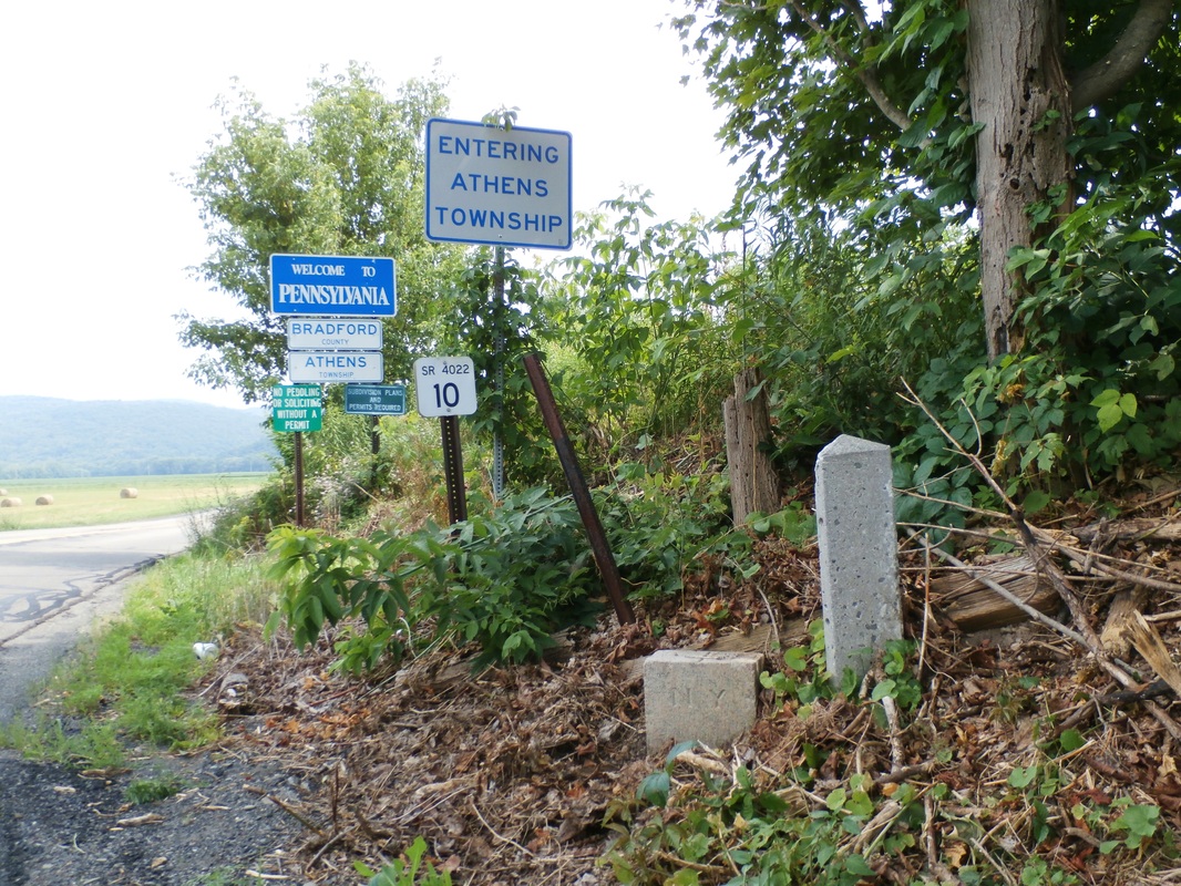
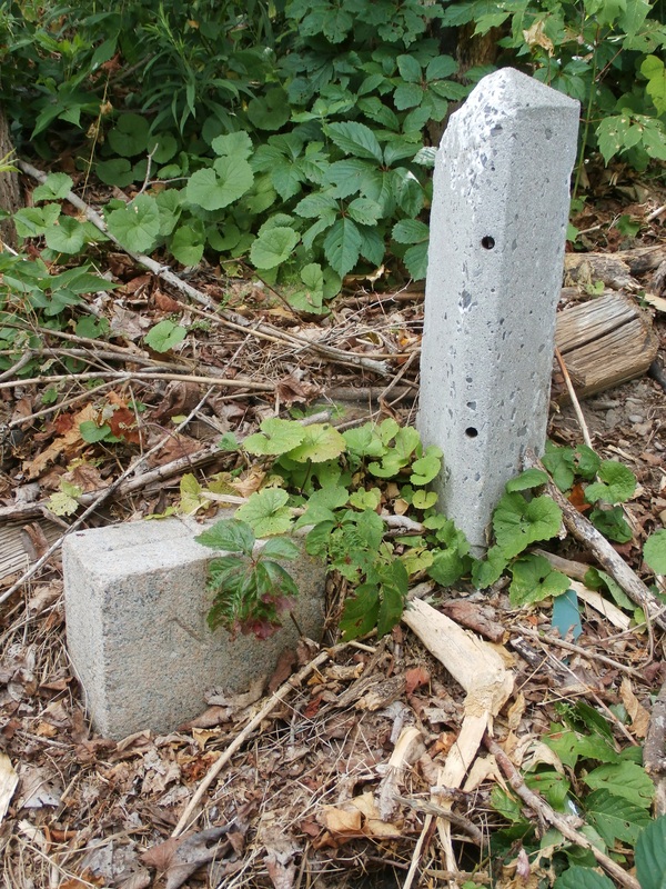
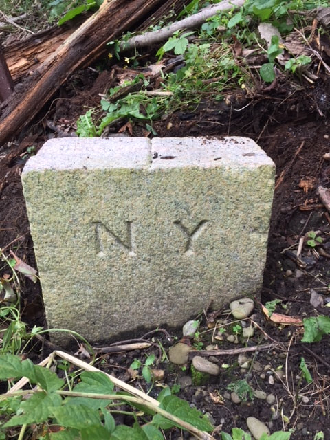
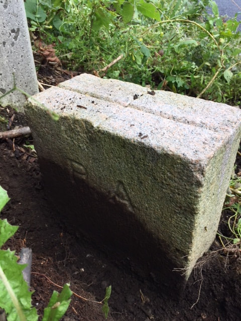
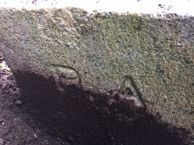
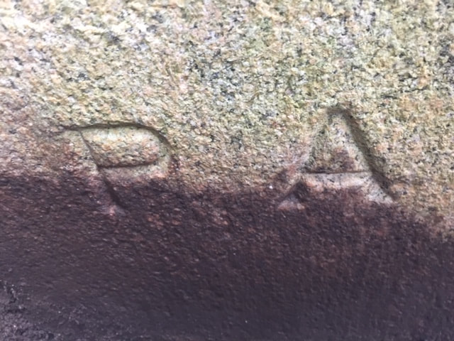
New Markers New reddish-gray granite markers were brought from Connecticut. These were four feet long and weighed 200-300 pounds each and were to be set at each mile and at each place the line was breached by a road, major stream or railroad. At its base an earthenware disc was buried, in the event the marker was disturbed. These stones were dressed six inches square on top and had a groove cut in the top to indicate the boundary line. On two opposite sides were the state designations and the miles from Delaware River. On Chemung County’s border there were 50 of these markers set. Twenty-two mile markers and twenty-eight secondary stones were set at roads and other line crossings.
Several of these stones can be located quite readily. The important No. 82 stone can be found along the east side of the Widger Rd. south of Caton. Other stones can be found: about a hundred feet east of the intersection of Christian Hollow Rd. and Stitzer Rd,; south of Wellsburg on the west side of Doty Hill Rd.; along the Wilawana Rd. on the west side of the state line. The writer has found others; where Bird Creek crosses, but it had been removed during culvert replacement and it is not known if it was every replaced, and in the woods west of Seeley Creek at State Line.
The Historical Society’s vice president Ted LaBrecque was recently pictured in the Star Gazette for his interest in locating some of these markers, particularly as they relate to the Pre-emption line, which at this time is also being resurveyed. Ted has obtained all sorts of interesting material from the N.Y.S. archives. Among this material is a map of the entire line showing each marker. The drawing is over 20 feet long. It shows the deviations between the two surveys. Accompanying it is a portion of the original survey team’s diary in narrative form relating some of the difficulties they had in the local part of the survey.
It has been decreed by both states that the markers will serve as the legal border on the ground. In the event a stone is missing, the line will be drawn between the two adjacent stones. This has resulted in a somewhat irregular line, not perfectly straight as depicted on most maps.
In any case, welcome home to New York, you former Pennsylvanians!
Credits:
Special thanks is due to Eric Gabrielson of Weiler Associates, surveyor and Ted LaBrecque for their sharing of their information and pictures with the author.
Historical Gazetteer of Tioga County 1787-1888 W.B.Gay
History of Chemung County, Towner 1892
New York, Guide to the Empire State, WPA writers project 1940
Pennsylvania Cavalcade, WPA writers project 1942
Pennsylvania A Guide to the Keystone State 1940
New York State Archives; Various materials relating to the N.Y. – PA border
Article taken from The Chemung Historical Journal Elmira, NY Vol.41, No. 3 March 1996
Elmira, Pennsylvania or Corning, Ithaca, or Binghamton, Pennsylvania. How do those names sound in your ears? It could have been.
In 1681 King Charles II, to settle a debt owed to Williams Penn’s father, granted to Penn Jr. the land in North America between the 40th and the 43rd degree of latitude west of the Delaware River to establish a home for his Society of Friends.
What matter that his predecessor, James I, in what was known as the Plymouth Grant of 1606, had already given the land between the 40th and 48th degrees indefinitely running from the Atlantic coast inland, to a Puritan group to establish a home in Massachusetts. Or that the Dutch were settling up the Hudson River valley already as far as Ft. Orange (Albany), effectively truncating the King’s generosity. It appears that North American land grants were a useful means for quieting dissenting groups or cheaply settling other obligations without the anticipation of repercussions. Out of sight, out of mind.
The Dutch problem was solved by driving them out of New Amsterdam and giving the rights to their holdings to the King’s brother (the Duke of York and Albany) in 1664. But this served only to make it an all-English conflict.
Inasmuch as this area was still largely wilderness, not much concern was evidenced about boundaries. As the war for independence drew nearer the Yankee-Pennamite Feud that had begun to simmer over the Massachusetts, New York and Pennsylvania border was put on a back burner as they all attended to more important matters.
The New Frontier Following the war, however, interest in the disputed area of central New York heightened. Soldiers who had passed through the region with General Sullivan’s campaign were impressed with the beauty and fertility of the country and brought their families here to seek their fortunes. The new American government was making land grants to veterans of the war, and the ferocious Iroquois had been subdued for being on the wrong side during the war. This was the new frontier.
It soon became evident that it would be necessary to establish jurisdictions in the region in order to govern these lands.
In 1786, at a conference in western Massachusetts the Treaty of Hartford was promulgated that established the western boundary of New York at the 77 degree of longitude. But where was its southern terminus?
By the action of the British Privy Council in 1879 the northern boundary of the Penn grant was established at the 42nd latitude rather than the 43rd. Thus we are residents of New York by five miles rather than residents of Pennsylvania by 70 miles. The 43rd degree of latitude passes just south of Syracuse.
The establishment of this line on the ground is another matter however. Anyone who has driven Rt. 17 east of Binghamton will certainly attest to the ruggedness of the terrain. The mountains are formidable and the rivers wide and often wild.
A commission was established in 1786. Gen. James Clinton, the governor’s brother, “Gen. John Hathorn (from Chemung area) and John Cantine Esq. represented New York. The starting point was to be in the middle of the Delaware River where the 42nd parallel crossed. It is near the present village of Hale’s Eddy.
Mile by Mile The surveyors worked as accurately as they could with the equipment of the day. Celestial sightings were necessary to forge their way through rugged country, much of it never before visited by man. Periods of unclear nights and inaccurate sightings led to slight deviations in the line. Every mile the surveyors set a piece of flat native stone with the mile noted and N.Y. and PA cared into the opposite sides, on the line.
The surveyors extended this line for ninety miles, which brought it to the west bank of the Tioga River just south of the famous Indian trail junction of Painted Post. This was deemed far enough west to anchor the so called Pre-emption line. Lands west of this line were to be owned by Massachusetts but governed by New York State. It was in effect New York’s western border. This point is located at milestone #82 on the N.Y. – Penn border.
Over the ensuing one hundred years the surveyed line came under increasing contention. Many of the stones disappeared or were destroyed by weather or farming activity as the area opened up to settlement. In 1886 a new commission hired the team of H.W. Clarke from New York and C.M. Gere from Pennsylvania to resurvey the line and replace the existing and missing stones. They were also charged with extending the line between the two states-for Massachusetts was no longer in the picture – all the way to Lake Erie.
The new team started at the Delaware River by erecting a special monument on the line, 600 feet west of the center of the river, determined from the average low water level. This monument was located on high ground where it would not be affected by the river’s flooding. With the newer equipment available they determined that the original surveyors had erred right at the beginning of the line’s course. As they proceeded west they discovered several errors, one of the greatest being just south of Elmira, a variance of almost 400 feet south thus favoring Pennsylvania.
New Markers New reddish-gray granite markers were brought from Connecticut. These were four feet long and weighed 200-300 pounds each and were to be set at each mile and at each place the line was breached by a road, major stream or railroad. At its base an earthenware disc was buried, in the event the marker was disturbed. These stones were dressed six inches square on top and had a groove cut in the top to indicate the boundary line. On two opposite sides were the state designations and the miles from Delaware River. On Chemung County’s border there were 50 of these markers set. Twenty-two mile markers and twenty-eight secondary stones were set at roads and other line crossings.
Several of these stones can be located quite readily. The important No. 82 stone can be found along the east side of the Widger Rd. south of Caton. Other stones can be found: about a hundred feet east of the intersection of Christian Hollow Rd. and Stitzer Rd,; south of Wellsburg on the west side of Doty Hill Rd.; along the Wilawana Rd. on the west side of the state line. The writer has found others; where Bird Creek crosses, but it had been removed during culvert replacement and it is not known if it was every replaced, and in the woods west of Seeley Creek at State Line.
The Historical Society’s vice president Ted LaBrecque was recently pictured in the Star Gazette for his interest in locating some of these markers, particularly as they relate to the Pre-emption line, which at this time is also being resurveyed. Ted has obtained all sorts of interesting material from the N.Y.S. archives. Among this material is a map of the entire line showing each marker. The drawing is over 20 feet long. It shows the deviations between the two surveys. Accompanying it is a portion of the original survey team’s diary in narrative form relating some of the difficulties they had in the local part of the survey.
It has been decreed by both states that the markers will serve as the legal border on the ground. In the event a stone is missing, the line will be drawn between the two adjacent stones. This has resulted in a somewhat irregular line, not perfectly straight as depicted on most maps.
In any case, welcome home to New York, you former Pennsylvanians!
Credits:
Special thanks is due to Eric Gabrielson of Weiler Associates, surveyor and Ted LaBrecque for their sharing of their information and pictures with the author.
Historical Gazetteer of Tioga County 1787-1888 W.B.Gay
History of Chemung County, Towner 1892
New York, Guide to the Empire State, WPA writers project 1940
Pennsylvania Cavalcade, WPA writers project 1942
Pennsylvania A Guide to the Keystone State 1940
New York State Archives; Various materials relating to the N.Y. – PA border
Milestone Marker placement, Wilawana Rd.on the west side of the state line, PA/NY
Click on photo to enlarge