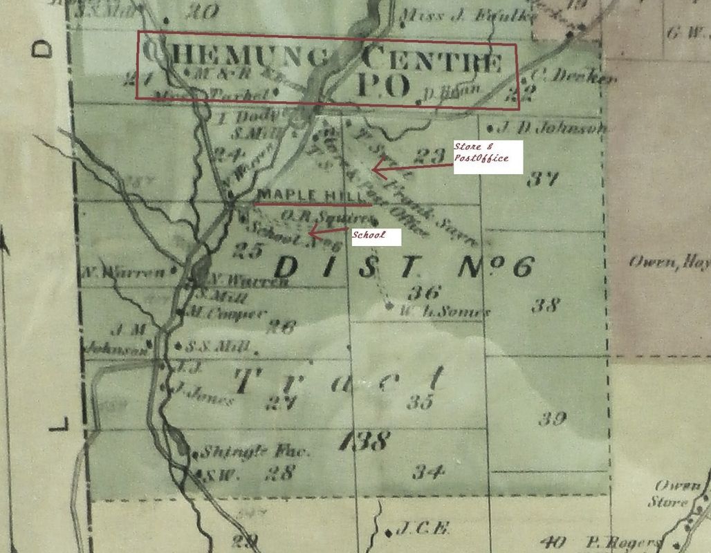
Chemung Centre - Hamlet in the Town of Chemung,NY
also known as Beantown, Double Mills & Maple Hill
& Hunter Tract
Chemung Centre, and also fondly known to the locals as Beantown, Double Mills & Maple Hill is a hamlet located approximately 7 miles north of Chemung proper, on Wynkoop Creek Road. It is indicated on the map to be the Hunter Tract of land. It is located on the banks of Wynkoop Creek. It was at one time called Double Mills, because of the mills on the creek. It was complete with a post office, general store and school house.
Also, located in the same area is Maple Hill State Forest. This forest was acquired under the terms of the Parks and Recreation Land Acquisition Bond Act in the 1960's. The current size is about 604 acres. More information can be obtained at the NYS Department of Environmental Conservation: http://www.dec.ny.gov/lands/38815.html
Also, located in the same area is Maple Hill State Forest. This forest was acquired under the terms of the Parks and Recreation Land Acquisition Bond Act in the 1960's. The current size is about 604 acres. More information can be obtained at the NYS Department of Environmental Conservation: http://www.dec.ny.gov/lands/38815.html
Maple Hill State Forest
Mary Ellen Kunst, Historian, Town of Chemung
Maple Hill State Forest is a 604-acre forest located in the Town of Chemung, Chemung County, NY. All state forests in New York State today are managed by the Department of Environmental Conservation, D.E.C. for multiple benefits to serve the needs of the people of New York. They stress the Forest focuses on rustic experiences with a limited amount of development.
Sustainable management practices ensure a perpetual supply of timber, a diversity of wildlife habitats, and compatible recreational opportunities with clean water. Activities encouraged are hiking, mountain biking, horse riding, cross country skiing, snow shoeing, geo-caching, camping and hunting. Motorized access is allowed by permit only. “Leave No Trace” principles are practiced.
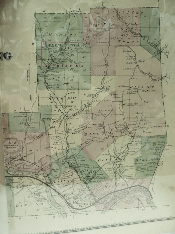
This forest was acquired under the terms of the Parks and Recreation Land Acquisition Bond Act in the 1960's. The forest area is comprised of a mix of open fields and relatively young forests of native trees. This area was heavily logged off in the mid-19th century: Pine and hardwoods were used for building and heating and Hemlock bark was used to make tannin for the leather industry. By 1915, trees were being replanted making the forests we see today a century old. Numerous saw mills located on Wynkoop Creek can be counted on the 1853 and 1869 county maps along with a shingle factory, all in and around Chemung Centre, a hamlet in the Town of Chemung. This area was also known as Double Mills and Beantown, named for the Bean Family who resided there in district #6 in Chemung. The name, Hunter Tract was given to this area of Chemung early on because of the untamed wilderness and sparse population, it was primarily used for hunting and later logging.
The Forest has limited road access and a tornado in the summer of 2012 made the only road into the state forest nearly impassable. The D.E.C. issued a press release in the fall to warn people of the dangers of the tornado damage, they stated: “DEC officials said this week the forest was heavily damaged by the summer tornado. The twister caused many trees to be uprooted, snap off and shatter, leaving debris still hanging in the tree tops, according to a DEC press release”.[1]
Looking back at the 1853 Chemung County Map, I did not find anyone actually living in the area of the State Forest but there were homes and farms in Chemung Centre lining the edge of the Forest. It was on the 1869 County Map where I found the name, W. L. Somes. I located a W.L. Somes, Town of Chemung, on a U.S. indexed County Land Ownership Maps. [2] Next, I found a W.E. Somes, Town of Chemung, in 1892 on a New York State Census. He was born in 1829. He and his wife, Nancy, were both 63 years old. He was listed as a laborer. [3] No doubt W.L. and W. E. were the same person. I was unable to find any other information on this couple but it would appear they lived up on the hill where the state forest is today. Their grave location is unknown.
The highest elevation in the Forest is 1653 feet. Maple Hill State Forest can be accessed by Pryne Road, off Wynkoop Creek Rd. (County Rt. #3). You can learn more about the Maple Hill State Forest through this webpage: http://www.dec.ny.gov/lands/38815.html
[1] The Steuben Courier Advocate, Press Release, October 13, 2012
[2] Source Citation:Collection Number: G&M_7; Roll Number: 7. Source Information:
Ancestry.com. U.S., Indexed County Land Ownership Maps, 1860-1918 [database on-line]. Provo, UT, USA: Ancestry.com Operations, Inc., 2010.
[3] Source Information: Ancestry.com. New York, State Census, 1892 [database on-line]. Provo, UT, USA: Ancestry.com Operations, Inc., 2012.Original data: 1892 New York State Census. New York State Education Department, Office of Cultural Education. New York State Library, Albany, NY.
Maple Hill State Forest is a 604-acre forest located in the Town of Chemung, Chemung County, NY. All state forests in New York State today are managed by the Department of Environmental Conservation, D.E.C. for multiple benefits to serve the needs of the people of New York. They stress the Forest focuses on rustic experiences with a limited amount of development.
Sustainable management practices ensure a perpetual supply of timber, a diversity of wildlife habitats, and compatible recreational opportunities with clean water. Activities encouraged are hiking, mountain biking, horse riding, cross country skiing, snow shoeing, geo-caching, camping and hunting. Motorized access is allowed by permit only. “Leave No Trace” principles are practiced.
This forest was acquired under the terms of the Parks and Recreation Land Acquisition Bond Act in the 1960's. The forest area is comprised of a mix of open fields and relatively young forests of native trees. This area was heavily logged off in the mid-19th century: Pine and hardwoods were used for building and heating and Hemlock bark was used to make tannin for the leather industry. By 1915, trees were being replanted making the forests we see today a century old. Numerous saw mills located on Wynkoop Creek can be counted on the 1853 and 1869 county maps along with a shingle factory, all in and around Chemung Centre, a hamlet in the Town of Chemung. This area was also known as Double Mills and Beantown, named for the Bean Family who resided there in district #6 in Chemung. The name, Hunter Tract was given to this area of Chemung early on because of the untamed wilderness and sparse population, it was primarily used for hunting and later logging.
The Forest has limited road access and a tornado in the summer of 2012 made the only road into the state forest nearly impassable. The D.E.C. issued a press release in the fall to warn people of the dangers of the tornado damage, they stated: “DEC officials said this week the forest was heavily damaged by the summer tornado. The twister caused many trees to be uprooted, snap off and shatter, leaving debris still hanging in the tree tops, according to a DEC press release”.[1]
Looking back at the 1853 Chemung County Map, I did not find anyone actually living in the area of the State Forest but there were homes and farms in Chemung Centre lining the edge of the Forest. It was on the 1869 County Map where I found the name, W. L. Somes. I located a W.L. Somes, Town of Chemung, on a U.S. indexed County Land Ownership Maps. [2] Next, I found a W.E. Somes, Town of Chemung, in 1892 on a New York State Census. He was born in 1829. He and his wife, Nancy, were both 63 years old. He was listed as a laborer. [3] No doubt W.L. and W. E. were the same person. I was unable to find any other information on this couple but it would appear they lived up on the hill where the state forest is today. Their grave location is unknown.
The highest elevation in the Forest is 1653 feet. Maple Hill State Forest can be accessed by Pryne Road, off Wynkoop Creek Rd. (County Rt. #3). You can learn more about the Maple Hill State Forest through this webpage: http://www.dec.ny.gov/lands/38815.html
[1] The Steuben Courier Advocate, Press Release, October 13, 2012
[2] Source Citation:Collection Number: G&M_7; Roll Number: 7. Source Information:
Ancestry.com. U.S., Indexed County Land Ownership Maps, 1860-1918 [database on-line]. Provo, UT, USA: Ancestry.com Operations, Inc., 2010.
[3] Source Information: Ancestry.com. New York, State Census, 1892 [database on-line]. Provo, UT, USA: Ancestry.com Operations, Inc., 2012.Original data: 1892 New York State Census. New York State Education Department, Office of Cultural Education. New York State Library, Albany, NY.
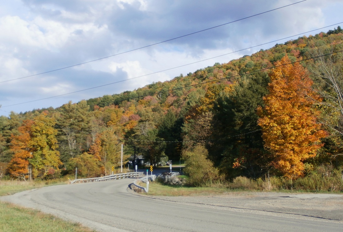
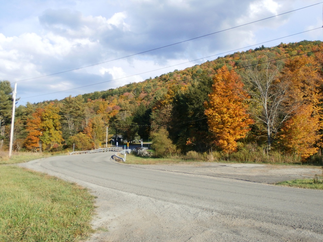
A fall view from Wynkoop Creek Road, "Maple Hill Locale" Town of Chemung, New York 2014
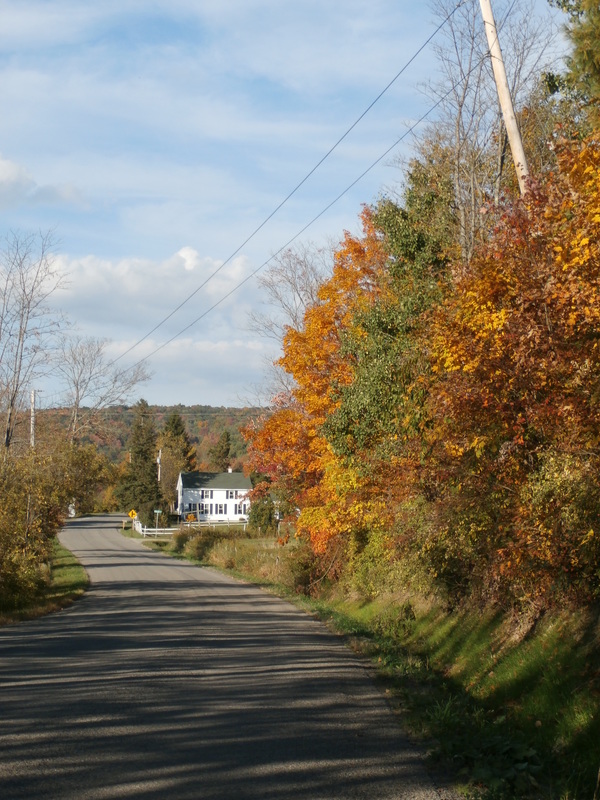
Bean town was originally called Chemung Centre a hamlet in the Town of Chemung
on County Route 3, Wynkoop Creek Road. It had it’s own post office and store. Named for the Fred Bean Family, the family burial plot in a nearby field was plowed under by a local farmer. Photo contributed by Mike Tuccinardi
on County Route 3, Wynkoop Creek Road. It had it’s own post office and store. Named for the Fred Bean Family, the family burial plot in a nearby field was plowed under by a local farmer. Photo contributed by Mike Tuccinardi
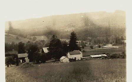
Chemung Centre (Beantown & Double Mills) - Hamlet in the Town of Chemung, NY
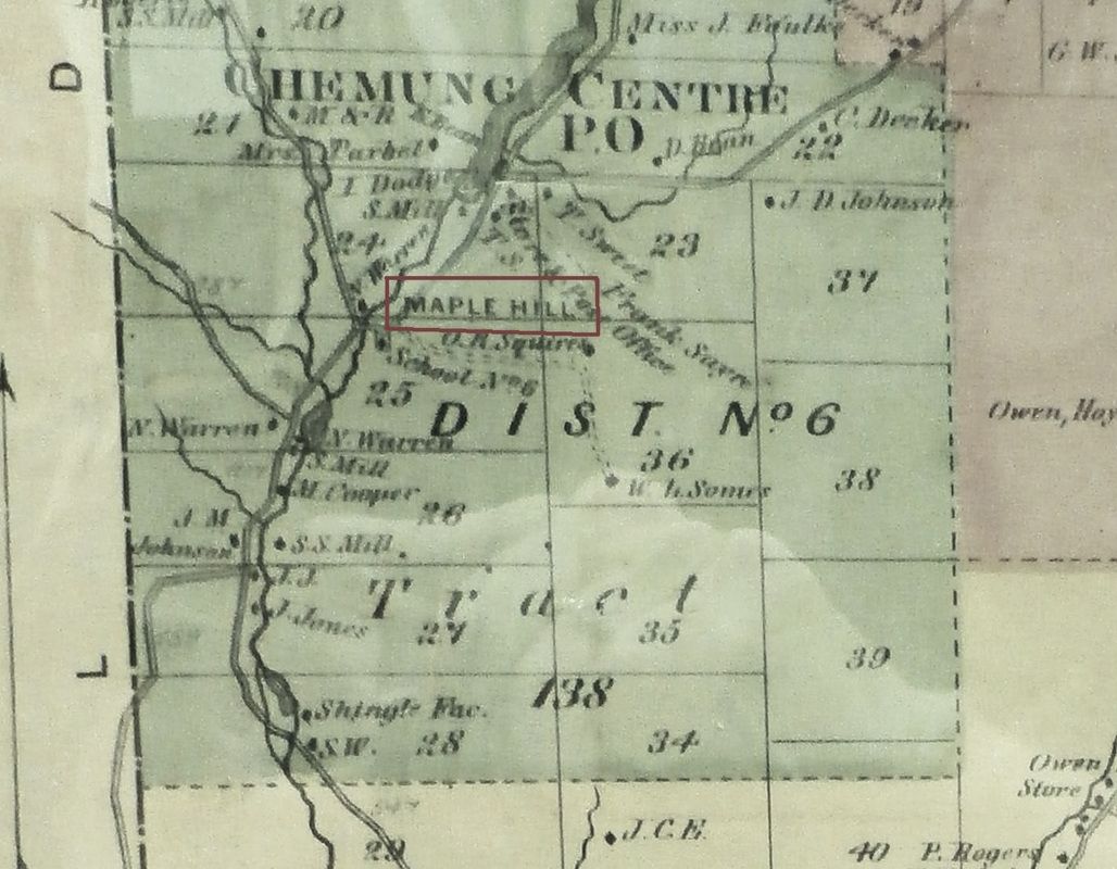
Maple Hill as indicated on the 1869 Town of Chemung Map.
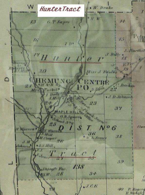
1869 map of Town of Chemung, notating the wording "Hunter Tract" on District #6.
|
Click on photo to enlarge
Location of Chemung Centre indicate by the red box, located in District #6, Town of Chemung, NY
|